 Onsite Visit Leads To Ledgewood-Bonair Landslide Quick Report
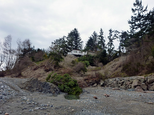
OLYMPIA – The Washington State Department of Natural Resources Division of Geology & Earth Resources has released their quick report on the Whidbey Island “Ledgewood-Bonair” landslide that occurred March 27, 2013. [Editor] Photo Credit: Washington DNR via Flickr [/Editor]
View the full quick report: http://www.dnr.wa.gov/publications/ger_qr_whidbey_island_landslide_2013.pdf
Key Points From The Report Include:
- The Ledgewood-Bonair Landslide (LB Landslide) On Whidbey Island, Island County, Washington Occurred Around 3:45 Am On March 27, 2013.
- It Is A Small Portion Of A Much Larger Landslide Complex, Approximately 1.5 Miles Long, That Was Prehistoric And May Date Back As Far As 11,000 Years.
- The Top Of The Landslide Scarp Averages 200 Feet Above Sea Level.
- The Landslide Pushed (Uplifted) The Beach As High As 30 Feet Above The Shore.
- The Toe (Front Of Landslide At The Beach) Is Slightly Over 1,100 Feet Long And Extends Approximately 300 Feet Into Puget Sound.
- Uplift Of The Beach Is Presumed To Have Been Relatively Slow (I.E., Over A Few Minutes).
- Wave And Tidal Action Is Actively Eroding The Toe With Small Sections (1-10 Cubic Feet) Observed Calving With The Rising Tide.
- The Volume Of Material Moved Was Approximately 200,000 Cubic Yards (Equivalent To 40,000 Dump Truck Loads).
- DNR Geologic Mapping From 2009 Shows The Extent Of The Landslide Complex (Polenz And Others, 2009,Http://Www.Dnr.Wa.Gov/Publications/Ger_gm68_geol_map_camano_24k.Pdf ).
- Where observed, the access road has been shifted approximately 80 feet down vertically and to the west.
Photos from geologist site visit are on the agency’s Flickr page. Available for media use with credit:http://www.flickr.com/photos/wastatednr/sets/72157633103436975/with/8597313215/
View updates of the landslide event on the agency’s “Ear to the Ground” blog:http://washingtondnr.wordpress.com/2013/03/27/whidbey-island-coupeville-landslide/
DNR: State’s Geologists
In addition to managing more than 5.6 million acres of state-owned lands and serving as the state’s wildland fire department, DNR houses the Washington State Geologist. The department regulates surface mining reclamation and provides technical assistance to citizens, industry and government on geologic hazards, forest stewardship, and other issues. Lands managed by DNR provide numerous public benefits, including outdoor recreation, native fish and wildlife habitat, and clean and abundant water.
Media Contact: Jessica Payne, Communications Public Information Officer, 360-584-7760,
# # #


