• Twitter
  • Facebook
  • LinkedIn
  • YouTube
GeoPrac.net

Our Sponsors

  • Home
  • About
    • Our Sponsors
  • Articles
  • News
    • Search By Tag
  • Events
    • Events Main
    • Add an Event
    • Webinars
    • Conferences
    • Calls For Abstracts
  • Resources
    • Links
  • Contact Us
News Ticker
  • [ August 24, 2023 ] Gannett Fleming Acquires DiGioia Gray Press Releases
  • [ July 30, 2023 ] An Introduction to AI and How It’s Currently Being Used by Geotechnical Engineers Software and Spreadsheets
  • [ July 19, 2023 ] Condon-Johnson & Associates Wins the ISM Fourth World Cup of Micropiles Press Releases
  • [ July 19, 2023 ] Civil Infrastructure Geoprofessionals are Ready to Adopt the Cloud, New Report Says Press Releases
  • [ July 19, 2023 ] Rolling Hills Estates Landslide, LA County Geologic Hazards
HomeNewsSoftware UpdatesRocscience’s 2020 – Year in Review

Rocscience’s 2020 – Year in Review

December 31, 2020 rockman Software Updates Comments Off on Rocscience’s 2020 – Year in Review
Rocscience's 2020 Year in Review

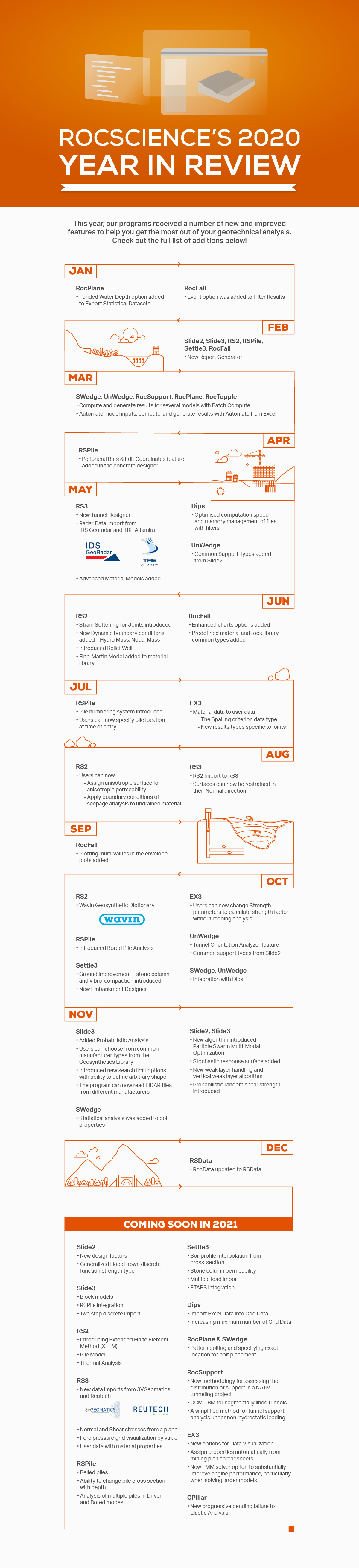
Geotechnical software company Rocscience has had a very busy 2020 with significant updates across their product list. They summarized their achievements in a nice infographic reproduced below. 

Share this:

  • Tweet
  • Email
  • Reddit
  • WhatsApp
  • More
  • Pocket
  • Share on Tumblr
  • rocscience
Quick clay landslide in Gjerdrum, NorwayPrevious

Quick Clay Landslide in Norway – Several Missing

Automated total station for geotechnical monitoring (credit Geo-Instruments)Next

Online Geotechnical Infrastructure Sensing and Monitoring Course

Related Articles

Screenshot from an early DOS version of Dips
Software Updates

30+ Years of Dips Software Development

April 15, 2021 rockman Software Updates Comments Off on 30+ Years of Dips Software Development

Engineering geologists and geological engineers are likely familiar with the stereonet software, Dips, by Rocscience. It is a great tool for plotting orientations of geological data from borehole or surface data. It’s hard to believe […]

Share this:

  • Tweet
  • Email
  • Reddit
  • WhatsApp
  • More
  • Pocket
  • Share on Tumblr
Software and Spreadsheets

Embracing Innovation with RocFall3 – Features, Application, and Integration

October 26, 2022 Rocscience Software and Spreadsheets Comments Off on Embracing Innovation with RocFall3 – Features, Application, and Integration

A 3D statistical analysis program, RocFall3 is designed to assess slopes at risk for rockfalls. The program can determine Energy, Velocity, and Bounce Heights along multiple rock paths. Not only can it spatially visualize runout distance on […]

Share this:

  • Tweet
  • Email
  • Reddit
  • WhatsApp
  • More
  • Pocket
  • Share on Tumblr
RS3 3D Finite Element Program for Slopes, Tunnels and Excavations
News

Rocscience RS3 Webinar Series and Product Roadmap for 2019-20

September 19, 2019 rockman News, Software Updates Comments Off on Rocscience RS3 Webinar Series and Product Roadmap for 2019-20

Geotechnical software creator Rocscience has been busy lately with no signs of stopping! They recently announced a webinar series for their RS3 program, a 3d finite element software program for modeling slopes, tunnels and various […]

Share this:

  • Tweet
  • Email
  • Reddit
  • WhatsApp
  • More
  • Pocket
  • Share on Tumblr

Our Sponsors

Upcoming Events

Check out these upcoming events for geoprofessionals! You can submit your own events, or go to calendar view as well.

Sep 21
September 21 - September 27

IAEG XIV Congress

China
Chengdu
China
Jul 5
July 5, 2024 - July 12, 2024

14TH ISL & RSS

Chambéry
Chambéry
France
View Calendar

Our Sponsors

Random Post by Image (Feeling Lucky?)

  • Bridge St bridge, Christchurch.
  • london_corinthia_hotel_craned_rig
  • 3D liquefaction map of Seoul S Korea
  • NASA's C-20A Earth science research aircraft with the UAVSAR slung underneath its belly lifts off the runway at Edwards Air Force Base on a prior radar survey mission.
  • An automated survey machine that will monitor multiple survey prisms along the Highway 99 tunnel alignment.
  • Drilling for presplit blasting for wind turbine foundations in Oklahoma
  • Greg Bentley gave a keynote on The Year in BIM Enhancements at the Year in Infrastructure 2014 Conference
Follow on Facebook
Recent Comments
  • Randy Post on Video of Highway 101 Landslide in California
  • GE Reviewer on San Francisco Millennium Tower Has Settled 16 Inches
  • Agus on New FHWA Soil Nail Manual Addresses LRFD, Hollow Bars
  • geoengineer Spain on Engineering Geologists vs Geological Engineers vs Geotechnical Engineers
  • Blaine J. Guidry, P.E. on A Whole Lotta Shakin’ Goin’ On: Center for Geotechnical Modeling Facilitates Seismic Research

Copyright © 2007-2020 by Randy Post